GeoHub Platform
The GeoHub Platform is designed to streamline and optimize the entire process of satellite imagery acquisition, analysis, and publication. This platform presents a multitude of advantages and features tailored for research and commercial projects, making it a standout choice for users requiring comprehensive and efficient geospatial data processing.
Key Features:
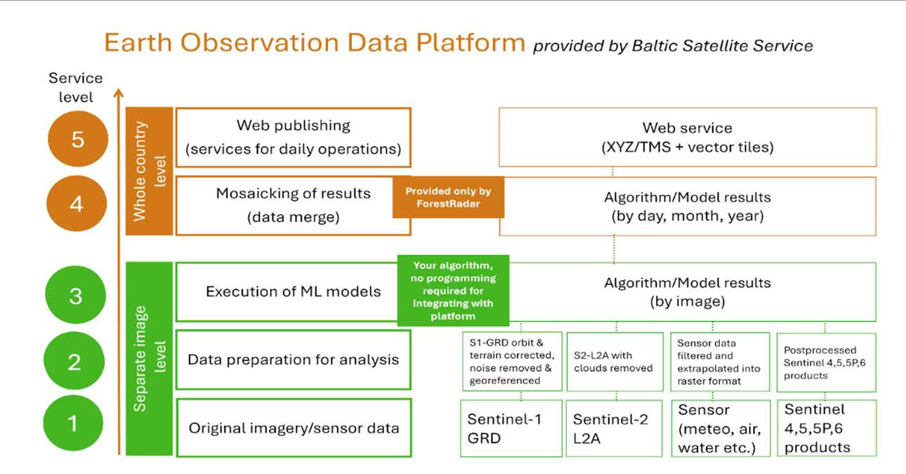
Diverse Data Processing and Access: Offers processing and access to a broad spectrum of source data like satellite imagery, LIDAR, meteorological, and sensor data for comprehensive environmental analyses.
Streamlined ML Model Integration: Facilitates easy execution of machine learning models across various environments and languages (MATLAB, R, Python, etc.) with support for major frameworks. Deployment is simplified through standard PIP requirements, negating additional programming.
Advanced Cloud Algorithm: Features a superior cloud detection and removal algorithm, merging KappaZeta and BSS innovations, to surpass existing solutions and ensure clearer data analysis.
Automated Mosaicking of Results: Automates mosaicking for large-scale analysis, crucial for seamless organizational integration and timely monitoring, eliminating manual effort for vast coverage areas.
Efficient Publishing of Data Access Services: Enables automated publishing of data in various formats (XYZ, MVT, SQLite/SpatiaLite, GeoJSON) for web and desktop applications, leveraging XYZ/TMS and MVT standards to reduce response times and hosting costs, supporting the development of new applications and broader area coverage more cost-effectively.
Key Benefits:
Integrated Solution: Provides a one-stop GeoHub platform for all steps from data acquisition to analysis and publication, eliminating the need to combine several platforms.
Time and Resource Efficiency: Saves hundreds of human hours per project on geospatial data preparation and processing workflow management, making large-scale projects feasible with limited resources.
Automated Processing: Enables the automation of complex tasks such as mosaicking and cloud removal, ensuring timely and efficient analysis.
Scalability: Capable of handling large-scale problems with ease, offering services at the individual image level up to country-wide analyses.
Flexibility: Supports a wide range of data types, including satellite imagery, drone data, LIDAR data, and more, catering to diverse project requirements
Future Developments
Integration of Additional Satellite Imagery and IoT Sensors: Plans to expand data sources to include newer satellite missions and IoT sensors for comprehensive monitoring capabilities.
Software Tools for Advanced Data Postprocessing: Development of tools to accommodate the integration and processing of additional data sources, enhancing the platform's versatility and applicability to various industries.
The GeoHub EO platform will be adapted and special features will be further developed to provide comprehensive functionality of the EO Baltic Government Services Platform (EO-BALP). Detailed information about EO-BALP project can be found here.